GIStandards
https://trbaker.github.io/GIStandards/
A machine analysis of geospatial language in US K-12 state curriculum standards
North Carolina
Report date: 2021-07-08
The frequency of all keywords found in this state's standards: 7
Comparable state score: 0.157 (median: .303, SD: .324)
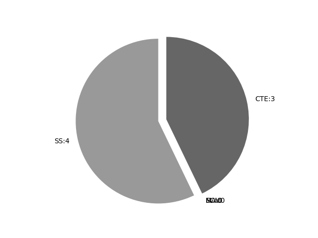
The frequency above is the sum of all keywords found in all of this state's four core academic standards and the state's CTE/career standards. This total count is broken down by keyword and discipline area below.
On this site, 'comparable scores' are calculated as: keywords found divided by total words in the standards document(s) - multiplied by 100,000. The comparable scores attempt to normalize data, accounting for very different sizes of curriculum guidance documentation.
Frequencies by keyword or phrase:Frequencies by discipline area: - SS: 4
(Comp: 2.838) - SC: 0
(Comp: 0.0) - MA: 0
(Comp: 0.0) - ELA: 0
(Comp: 0.0) - CTE: 3
(Comp: 0.225)
Support files: Examples of keyword use by discipline area (and document): - CTE
- 2021 CTE Essential Standards and Course Inventory.pdf, page:56, position:1797
process to create systems such as a cloud-based digital storage system for images. Students will design a system to automatically collect and report data on highway usage. They will apply a geospatial system to map a store and develop a database tha - 2021 CTE Essential Standards and Course Inventory.pdf, page:56, position:2071
habits. Through these projects, students will learn about data management and logic-based queries by collecting data, using the Global Positioning System (GPS) and analyzing data utilizing a geographic information system (GIS). Th ey will learn how to automate data col - 2021 CTE Essential Standards and Course Inventory.pdf, page:56, position:2101
students will learn about data management and logic-based queries by collecting data, using the Global Positioning System (GPS) and analyzing data utilizing a geographic information system (GIS). Th ey will learn how to automate data collecti
- SS
- seventh.pdf, page:1, position:409
of bus bus stop) and cardinal directions (north, south, east, west) to locate community markers.7.G.2.2 Use maps, charts, graphs, geographic data and available technology tools (i.e. GPS and GIS software) to interpret and draw conclusions abou - second.pdf, page:0, position:638
Grade Social StudiesGeography and Environmental LiteracyEssential StandardsExtended Essential Standards2.G.1 Use geographic representations, terms and technology to process information from a spatial perspective.Understand a picturesymbol can r - eighth.pdf, page:0, position:983
restoration and alternative sources of energy).EX.8.G.1.3 Use a map to get to an unfamiliar location within the school andor community.EC.8.G.1.4 Use available technology tools (i.e., GPS and GIS software) to locate community markers which will - first.pdf, page:0, position:801
Grade Social StudiesGeography and Environmental LiteracyEssential StandardsExtended Essential Standards1.G.1 Use geographic representations, terms and technologies to process information from a spatial perspective.Understanding locationEX.1.G.1 I
On this site, 'comparable scores' are calculated as: keywords found divided by total words in the standards document(s) - multiplied by 100,000. The comparable scores attempt to normalize data, accounting for very different sizes of curriculum guidance documentation.
(Comp: 2.838)
(Comp: 0.0)
(Comp: 0.0)
(Comp: 0.0)
(Comp: 0.225)
- 2021 CTE Essential Standards and Course Inventory.pdf, page:56, position:1797
process to create systems such as a cloud-based digital storage system for images. Students will design a system to automatically collect and report data on highway usage. They will apply a geospatial system to map a store and develop a database tha - 2021 CTE Essential Standards and Course Inventory.pdf, page:56, position:2071
habits. Through these projects, students will learn about data management and logic-based queries by collecting data, using the Global Positioning System (GPS) and analyzing data utilizing a geographic information system (GIS). Th ey will learn how to automate data col - 2021 CTE Essential Standards and Course Inventory.pdf, page:56, position:2101
students will learn about data management and logic-based queries by collecting data, using the Global Positioning System (GPS) and analyzing data utilizing a geographic information system (GIS). Th ey will learn how to automate data collecti
- seventh.pdf, page:1, position:409
of bus bus stop) and cardinal directions (north, south, east, west) to locate community markers.7.G.2.2 Use maps, charts, graphs, geographic data and available technology tools (i.e. GPS and GIS software) to interpret and draw conclusions abou - second.pdf, page:0, position:638
Grade Social StudiesGeography and Environmental LiteracyEssential StandardsExtended Essential Standards2.G.1 Use geographic representations, terms and technology to process information from a spatial perspective.Understand a picturesymbol can r - eighth.pdf, page:0, position:983
restoration and alternative sources of energy).EX.8.G.1.3 Use a map to get to an unfamiliar location within the school andor community.EC.8.G.1.4 Use available technology tools (i.e., GPS and GIS software) to locate community markers which will - first.pdf, page:0, position:801
Grade Social StudiesGeography and Environmental LiteracyEssential StandardsExtended Essential Standards1.G.1 Use geographic representations, terms and technologies to process information from a spatial perspective.Understanding locationEX.1.G.1 I
